IFR Navigation Planner icon
Pre-flight IFR route & procedure study
Coming sooniPhone · iPad7-day free trial

IFR Navigation Planner

IFR route building, pre-flight briefing and performance planning in one app, from the departure runway to the missed approach. Built for pilots and students who want to study a flight properly before they fly it.

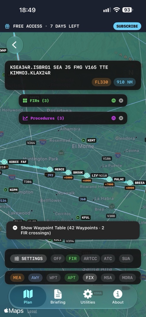
IFR Navigation Planner route map with FIR and procedure layers
The problem it solves

Ten sources, one briefing.

Before an instrument flight a pilot has to gather a lot of separate information and piece it together by hand, usually with several websites, paper or PDF charts and manual calculations. IFR Navigation Planner puts it all on one map and one briefing screen.

  • The route and its departure and arrival procedures
  • Minimum safe altitudes and terrain awareness
  • Weather along the route and hazards you fly through
  • Winds at cruising altitude for a realistic EET
  • Airspace notices for your airports and FIRs
  • Whether you need an alternate, and whether yours meets minimums
Features

Everything for the IFR study session

Plan your route your way

  • Auto Route generates a complete IFR plan between two airports
  • Step by step with SIDs, airways, STARs and approaches, including transitions
  • Import route text straight from an OFP or another app
  • Save, review and edit your plans at any time

See the whole picture

  • Your route with SID, STAR, approach and missed-approach legs
  • MSA sectors and grid MORA for terrain awareness
  • Controlled and restricted airspace and ARTCC boundaries
  • Current US navigation data, updated every cycle

Brief smarter

  • METAR and TAF for departure and destination
  • D-ATIS runway in use, shown next to the runway in your plan
  • Planned vs advised runway: replan in a few taps, keeping your airway connection
  • NOTAMs for your airports and the FIRs along your route
  • Alternate suggestions based on TAF

Winds aloft & EET

  • Enter a cruise altitude and the app flies your route through the forecast winds
  • Wind, temperature, TAS, GS and Mach at every waypoint
  • TOC and TOD from your own performance profile
  • IAS/Mach crossover handled automatically
  • Leg times and total EET

Weather hazards on your route

  • G-AIRMET and SIGMET areas drawn over your route
  • TFM Convective Forecast (TCF) with echo tops
  • Vertical flight profile showing hazards you climb, cruise and descend through
  • Winds aloft map along your route

Utilities

  • Magnetic variation for any coordinate (World Magnetic Model, on device)
  • Navigation data updates each AIRAC cycle
  • Performance profile for your aircraft: takeoff, climb, cruise IAS/Mach, descent and approach speeds
  • Alternate planning per 14 CFR 91.169 (advisory)
Screenshots

A tour on iPhone

On iPad

Room to see the whole route

On iPad the map gets the full screen: ARTCC, MSA, restricted airspace and procedure layers, plus winds aloft from 3,000 ft to FL530.

Full map with ARTCC, MSA and procedures
Winds aloft by altitude along the route
How it works

From airport pair to full briefing in minutes

Build the route

Pick departure and destination runways and let Auto Route build the plan, or paste route text from your OFP.

Check the map

See SIDs, STARs, approach and missed approach, then switch on airspace, MSA and nearby waypoints.

Run the briefing

Enter altitude and speed. The app computes EET with live winds and shows hazards, NOTAMs and the flight profile.

Plan the alternate

Set a departure time to see whether an alternate is required, and whether your choice meets forecast minimums.

Pricing

Try every feature free for 7 days

No account, no login and no payment details to start. After the trial, choose a subscription to keep full access.

Free trial

7 days

Every feature unlocked from first launch.

Monthly

Auto-renewing

Full access, billed monthly through your Apple Account.

Payment is charged to your Apple Account at confirmation of purchase. Subscriptions renew automatically unless cancelled at least 24 hours before the end of the current period. Manage or cancel any time in your App Store account settings. See the Terms of Use (EULA) and Privacy Policy.

Data sources

Official, public data. No tracking.

The app has no user accounts, no analytics or advertising SDKs and no AI services. Your location, if you allow it, is used only while the app is open and is never sent anywhere.

ServiceProviderUsed for
Aviation Weather CenterNOAA / National Weather ServiceMETAR, TAF, G-AIRMET, SIGMET, winds and temperatures aloft, TCF
D-ATISPublic third-party serviceRunway in use and airport conditions
NOTAM relayDeveloper server, FAA source dataNOTAMs for airports and FIRs along the route
Aeronautical dataFAA data, published by the developerAirports, airways and procedures, updated each cycle
World Magnetic ModelNOAA, computed on deviceMagnetic variation for any coordinate
Apple MapKit & StoreKitAppleMap display, subscriptions and restore purchases

Not for operational navigation

IFR Navigation Planner is a study and simulation tool for pre-flight planning and education. It is not approved for in-flight or operational navigation and is not a substitute for official charts, publications, weather briefings, NOTAMs or ATC instructions. Automatically generated routes are indicative only. Always verify all information with current official sources. The pilot in command remains solely responsible for the safety of the flight.

Be first to fly with IFR Navigation Planner

The app is on its way to the App Store. Send a note and you will hear the moment it is live.